What’s the quickest way from the bottom of Bay Street to Eglinton and Yonge? And how about from NYU to Times Square? Or from Checkpoint Charlie to Unter den Linden? If you are familiar with Toronto, New York City, and Berlin, then you can probably answer those questions with relative ease. (Hint: don’t try to walk to Eglinton, especially during the 11½ months of winter.)
But how do we know the answers to such questions about navigation in familiar environments? What mental representations are we using to answer such questions?
This question is of not only of basic scientific interest but also carries important practical implications—for example, what’s the best way to display information on a GPS (or “SatNav” in the UK) in your car? Should north be up or should the direction in which you are traveling be at the top?
A recent article in the Psychonomic Bulletin & Review addressed some aspects of this question. Researcher Tobias Meilinger and colleagues approached people seated at street cafes in Tübingen, Germany, and asked them to participate in a navigation task. (In case you don’t know Tübingen, it’s the German equivalent of Pittsburgh in terms of navigability, except considerably more so because the roads date back to the Middle Ages.)
Participants were asked to arrange 10 tags that were labeled with familiar Tübingen landmarks on a blank sheet of paper to represent their actual positions in the city.
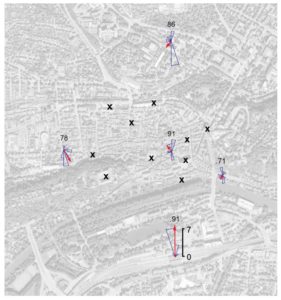
Meilinger and colleagues manipulated several variables that previous research had identified as potentially affecting people’s navigational abilities. First, they approached participants in various different locations in the city, as shown in the figure below.

The “X”s in the figure indicate the landmarks that participants had to place on the blank paper, and the origins of the red arrows represent different street cafes in which the participants happened to be sitting when they were approached by the experimenter. How would one’s position relative to the landmarks affect the construction of the map?
In addition, the researchers selected participants according to their body position: Did they happen to face east, west, north, or south? How would one’s body position—that is, the direction in which one is facing—affect the placement of landmarks on the map?
The results were intriguing and relatively straightforward.
First, people aligned their maps with their location and body position, rather than with an absolute reference point, such as north. So if you were in Buenos Aires then New York would be on top of your map, and if you were at the North Pole then New York would be at the bottom. In the figure above, this is indicated by the red arrows which represent the orientation of the maps that people produced in those locations. Note how that arrow faces up (north) for the location below (south) of the landmarks, whereas it faces down (south; or nearly so) for the location to the north of the landmarks. In addition, those map arrangements would be shifted slightly, depending on whether you were facing east or west.
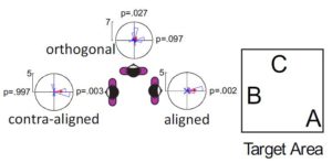
Second, the two variables—location relative to landmarks and body position—traded off in interesting ways when they were placed in opposition. This is shown in the figure below, which shows the effect of body position on orientation of the constructed map, for a location to the west of the area in which the landmarks (A, B, and C) were located.

When body position was aligned with the location, such that the participants was facing in the direction of the landmarks, then the map was consistently oriented towards the target area. This is shown by the red arrow for the “aligned” circle, and also the blue histogram within the circle which represents the distribution of map alignments for participants in that location and alignment.
When body position and location perspective were orthogonal, people chose one of two orientations: They either drew the map based on which way they were facing (so if facing east in Buenos Aires, New York would be on the left) or they drew it based on where they were located (if in Buenos Aires, New York is on top).
Finally, when people were facing away from the area in which the landmarks were located, they again produced maps that were orientated based on physical location rather than body orientation—so if you are facing the South Pole in Buenos Aires, New York would still be on top.
The main novelty of the research by Meilinger and colleagues is that it shows the importance of location in people’s construction of their environment. Whereas previous research had shown the effect of body orientation, it had been unknown how this variable would interact with a person’s location. As the figure above show, this matters a great deal.
What is particularly intriguing about those results is that previous research has shown that people’s long-term memory representations of their city of residence is encoded with north facing up (coincidentally, this research was done in Tübingen as well). This earlier result implies that people must be mentally re-aligning their long-term memory representation when they are sitting at a café and reconstruct landmarks on a blank piece of paper in an orientation other than north. Why would people incur this mental cost and cognitive effort to re-align their long-term memory representation?
Meilinger and colleagues suggest that the mental effort the re-alignment entails may be worth it because it “enables the navigators to directly approach such locations or to estimate their distance and direction (e.g., by pointing).”
The utility of this re-alignment becomes readily apparent with a GPS in your car: if the map is oriented in your direction of travel, everything makes sense and navigation is a breeze. If the map is instead oriented so that north faces up, your navigation turns into a constant Stroop task.
